Gronk!
Senior Member

124 Street Renewal | City of Edmonton
124 Street between 109A Avenue and 118 Avenue has been renewed and is open for Edmontonians to enjoy.www.edmonton.ca
Look what they dug up from under 124 St

124 Street Renewal | City of Edmonton
124 Street between 109A Avenue and 118 Avenue has been renewed and is open for Edmontonians to enjoy.www.edmonton.ca
"Marlis Foth of the City of Edmonton says plans were already in the works to honour the railway as part of the streetscape project, and they now hope to incorporate the historic ties."Look what they dug up from under 124 St
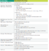
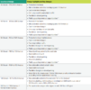
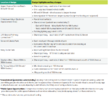
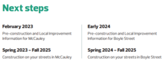
I love the idea of 96/Church street being a the major North-South bike/walking street. This really should be more of an Edmonton icon than a curiousity in some serious sketchy area... Or as my college J school prof said about when she did a CBC Radio series on it "Honey, you're on Ho Row!" which is still how unfortunately I refer to it in my own mind. That's not a good look but also it is what it is. The world's oldest profession will definitely outlast any of the "woowoo" religious cults that used to occupy any number of those churches before their decline and conversion...Boyle Street and McCauley
Project Update - June 2022
We are currently in the Community Feedback on Final Design phase of Neighbourhood Renewal. The Project Team will spend the next 10 months working out the details of the designs and getting them ready for the construction team to take over in spring 2023.
Final Design Information Booklet
View in PDF format (10.9 MB)
The survey will be available until June 30, 2022.
View attachment 408441View attachment 408440View attachment 408446View attachment 408445View attachment 408444View attachment 408443View attachment 408442
For comparison, here's the active transportation map from the draft design.
View attachment 408447
This is their plan to get around the Living Bridge (bottom right)
View attachment 408448
Hoping that last portion of the bike lane (and bike sensors to cross 87 and 82) are done by September. I've been avoiding it by taking 106 over to the east for the past few weeks after I almost got hit by a construction truck down there earlier this month.No photos as I didn't want to stop in the road amidst all the construction, but 110 St in Garneau now has new sidewalks on the east side and new curbs in place around 79 Ave to 81 Ave
The ones that are by the curbs are to to stop poeple from parking to close to crosswalks or intersection. Don't know about the islands.Possibly tangential question, but I've noticed some of these makeshift curb extensions/traffic islands popping up in some SW neighbourhoods (mainly those with collector roads that are waaaaaaay too wide, yay 1990s-2000s surburb designs). Does anyone know if this is a city initiative or have any background info on them? Attached photos are from Riverbend Road through Brander Gardens (there's also some on 40 Ave near the Petrolia strip mall in the Royal Gardens/Duggan area and some in Rutherford). I can think of one or two more areas that could use these.
View attachment 415499View attachment 415500View attachment 415501
Possibly tangential question, but I've noticed some of these makeshift curb extensions/traffic islands popping up in some SW neighbourhoods (mainly those with collector roads that are waaaaaaay too wide, yay 1990s-2000s surburb designs). Does anyone know if this is a city initiative or have any background info on them? Attached photos are from Riverbend Road through Brander Gardens (there's also some on 40 Ave near the Petrolia strip mall in the Royal Gardens/Duggan area and some in Rutherford). I can think of one or two more areas that could use these.
View attachment 415499View attachment 415500View attachment 415501
Awesome, thanks for the links and info. Ended up reading most of that Brander Gardens and every problem listed there is pretty much as expected and could probably be applied to majority of the circa 1980s-2000s built suburbs. And when you add in curvy roads into the equation you get speeding cars weaving everywhere because they think the parking lane+driving lane is one and the same. Hoping to see more of these initiatives soon!I worked a co-op student term with CoE Safe Mobility this past winter and these were added as prelim installations for Brander Gardens Street Labs. The similar temporary curb extensions popping up elsewhere city-wide are part of the Safe Crossings Program this year.
