CplKlinger
Senior Member
Not sure where to put this, but someone on Reddit wrote up an interesting post about their 'dream' rapid transit network. What do you folks think about it? It's not mine, but I'd still love to hear some thoughts on it.
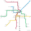
Their proposed LRT routes.
"-Capital Line Extension (Blue) - Continues west down Jasper, north up 124th Street, and ends at Westmount Mall. All underground.
-Metro Line (Red) - Same as planned by the City of Edmonton minus a few stops on the south end of the line.
-Valley Line (Green) - Same as planned by the City of Edmonton.
-South Line (Yellow) - At-grade up Terwillegar Drive to McKernan/Belgravia, underground from Health Science to 75th Street, at-grade into Sherwood Park.
-Downtown Connector (Orange)
-Convert the historic streetcar line into a real part of the transit system.
-Install modern streetcars and build out actual stations along the line.
-Connect to the Capital Line, Jasper Ave, and Alberta Rail Transit Station"
Alberta rail:
"-Provincial passenger line that uses old rail lines.
-Edmonton's station is at CPR Irvine -- the former rail yard south of Whyte that is currently empty -- which still has a rail corridor running south through the city towards the airport and could realistically accommodate a station of this sort in a pretty central location.
-Edmonton Irvine - Edmonton Airport - Red Deer - Calgary Airport - Downtown Calgary"
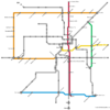
Their proposed BRT routes.
"BRT network would use a system of dedicated bus lanes/bridges and traffic light priority.
-Orange Line (Northwest Circulator) - Starting at Clareview station, the line runs along 137th Ave, down 170th Street connecting to WEM, then down 87th Ave connecting to the University at Health Sciences.
-Red Line (North-South Express) - Runs downs 97th Street. Just south of 111th Ave it turns onto 101st Street with a stop between at 110a Ave. Continues through downtown on 101st and diverts off Bellamy Hill Road onto a dedicated BRT road through Rossdale and across the river connecting to Tommy Banks Way/102 Street. Includes a stop just north of Whyte and at the Alberta Rail Transit Station. Continues south either along the rail corridor or Calgary Trail (got lazy at this point tbh).
-Green Line (East End Connector) - Runs down 75th Street connecting Coliseum to Davies Station.
-Yellow Line (Downtown-East Express) - Runs along 98th Ave from Sherwood Park to Downtown.
-Blue Line (South Side Connector) - Runs along 23rd Ave connecting Mill Woods to Terwillegar with stops at South Edmonton Common and Century Park."

Their proposed LRT routes.
"-Capital Line Extension (Blue) - Continues west down Jasper, north up 124th Street, and ends at Westmount Mall. All underground.
-Metro Line (Red) - Same as planned by the City of Edmonton minus a few stops on the south end of the line.
-Valley Line (Green) - Same as planned by the City of Edmonton.
-South Line (Yellow) - At-grade up Terwillegar Drive to McKernan/Belgravia, underground from Health Science to 75th Street, at-grade into Sherwood Park.
-Downtown Connector (Orange)
-Convert the historic streetcar line into a real part of the transit system.
-Install modern streetcars and build out actual stations along the line.
-Connect to the Capital Line, Jasper Ave, and Alberta Rail Transit Station"
Alberta rail:
"-Provincial passenger line that uses old rail lines.
-Edmonton's station is at CPR Irvine -- the former rail yard south of Whyte that is currently empty -- which still has a rail corridor running south through the city towards the airport and could realistically accommodate a station of this sort in a pretty central location.
-Edmonton Irvine - Edmonton Airport - Red Deer - Calgary Airport - Downtown Calgary"

Their proposed BRT routes.
"BRT network would use a system of dedicated bus lanes/bridges and traffic light priority.
-Orange Line (Northwest Circulator) - Starting at Clareview station, the line runs along 137th Ave, down 170th Street connecting to WEM, then down 87th Ave connecting to the University at Health Sciences.
-Red Line (North-South Express) - Runs downs 97th Street. Just south of 111th Ave it turns onto 101st Street with a stop between at 110a Ave. Continues through downtown on 101st and diverts off Bellamy Hill Road onto a dedicated BRT road through Rossdale and across the river connecting to Tommy Banks Way/102 Street. Includes a stop just north of Whyte and at the Alberta Rail Transit Station. Continues south either along the rail corridor or Calgary Trail (got lazy at this point tbh).
-Green Line (East End Connector) - Runs down 75th Street connecting Coliseum to Davies Station.
-Yellow Line (Downtown-East Express) - Runs along 98th Ave from Sherwood Park to Downtown.
-Blue Line (South Side Connector) - Runs along 23rd Ave connecting Mill Woods to Terwillegar with stops at South Edmonton Common and Century Park."
Last edited:
