News   Apr 03, 2020
 7.4K     3 
News   Apr 02, 2020
 7.9K     0 
News   Apr 02, 2020
 2.6K     0 

Fantasy Transit Maps

I actually quite like this. It incorporates a lot of the things I see as both realistic (long-term) and no-brainers for the future of rapid transit in Edmonton. Having the Metro Line split off at South Campus and head down Terwillegar to Windermere, the 87-Whyte Ave LRT, something down 137th Ave, etc. I didn't think about a Whitemud line but I also quite like that. The Jasper line is the only major one I have gripes with. The part in the central zone makes a lot of sense and is something I've thought about too -- having something down Jasper and 124th through Oliver/Westmount. But I think having it rip through a bunch of industrial areas in the NW doesn't make as sense. I'd either continuing down 124th to 118th and then switching to 127th St past Calder all the way to the Palisades or have it turn off 124th at 111th and then go down Groat/St Albert Trail to Village Tree. I also think having what is the Festival Line on your map go all the way down 118th Ave through Alberta Ave/Parkdale to NAIT and then interlining with the Metro Line makes more sense.

Thank you for the response!! I really like your map too esp the addition of the BRT and RER lines. Honestly I do not agree with all of the things I put on mine like the NW orange line, I did that a loooong time ago lol. I think I'll either cut it off at Westmount Mall or do a route similar to your NW one.

Also wanna point out that I actively tried to have an equitable distribution of rapid transit for the North, South and West sides of the city ("East Edmonton" is like 3 neighborhoods and even then I tried)
Wow, I've never seen or heard of this plan before! Thanks for sharing @Yeggy

Where do y'all make these maps?
MyMaps!

View attachment 523701
This is (I think) what the network looks like laid out over the city. Very impressive considering the population of the city at the time. It was difficult as some of the street names are different and a lot of them have changed alignments at least a bit over the years. Mainly in the Cromdale Area, where I basically gave up since the road network is completely different.
View attachment 523704
Here's an alternate history map of what might have been if the city hadn't removed the streetcar network, but instead kept, upgraded and worked on it like Toronto or Melbourne.
Woah! Personally, I've honestly never really considered a streetcar network for Edmonton and what it might look like, but this is really interesting. With a network like this central Edmonton would just be such a great place to live, and the density of lines in Boyle Street may have helped make it a more relevant and cared-for area in time, but here we are 😕. Thanks for sharing @erudyk_29 !
 
Last edited:

I have updated it with my vision for the LRT, within Edmonton confines only (didn't dabble into the CMA).
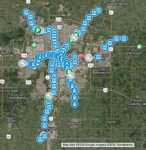
Schematic Map:

metromapmaker-2.png


Explaining every line:

High Floor Lines

Line 1:
Main north-south connector.
It bisects the city in two halves, connecting from the Garrison to EIA.
Length: 44km
Stations: 27
Frequency: 3 minutes

It runs at grade, partial grade separation (like the current Capital line down 111 st) from 176 ave to 127 ave, where it goes elevated all the way down to 118 Ave, where it goes back to being at grade and meets Line 3 in Blatchford, where it shares the tracks for two stations, and goes underground under Princess Elizabeth Ave and continues under 109 st all the way until it meets the existing tunnel, at the Government Centre station.
Between Government Centre and Heritage Valley, it essentially follows the current plans for the Capital Line, continuing down to EIA, where it has 2 stops: 1 at the cargo centre and 1 at the terminal. A few changes are to be made: the whole section between Health Sciences and the point where it resurfaces on 111 St is now underground, Southgate Station actually connects directly to the mall, and the Transit Centre is redesigned to be one massive station, instead of the weird bus shelters.

Line 2 - Northeast - West connector
Connects Gorman to West Edmonton Mall
Length: 27km
Stations: 24
Frequency: 3 minutes

From Gorman to Corona it follows the current alignment and plans for the current Capital Line, with the addition of a station at McCauley. A few fixes are done here: it dives underground the Stadium station until it's past 82 st. From Corona, it continues west under Jasper Avenue, before turning north on 124 st, where it connects with Line 5 (current Valley Line) and then moves back west under 111 Ave, where it connects to Coronation Park and TWOS. It then moves to being at grade/trenched, going SW, through Canora and connecting again with Line 5 in Jasper Place, where it turns west towards Terra Losa, where it goes underground again at 178 st and then finishes at the WEM.

Line 2 - B - Highlands - Beverley extension
Length: 5.5km
Stations: 5
Frequency: 9 minutes

Short extension going under 112 Avenue, starting at the Stadium station and going east through the Highlands, until 50 St, where it moves north for a couple of blocks, and the east again to Beverly. It adds another 4 stops to the line, connecting Concordia University to the system.

The scheduling for Line 2/2-B works in the following way: Line 2 -> 5min -> Line 2 -> 5min -> Line 2 -> 5min -> Line 2-B -> 5min -> Line 2

Line 3
- NW-SW
Connects Campbell Rd and Windermere
Length: 34km
Stations: 26
Frequency: 3 minutes

The NW alignment follows exactly the plans for the current Metro Line, all the way to South Campus station with a few changes: It goes underground after NAIT station, until it crosses 107 ave, where it goes back to how it is today.
From South Campus station, it goes west, underground, adding another station at the west side of the campus and then crossing under Whitemud Dr., adding a stop at Fort Edmonton Park, where it turns south, at grade and parallel to Whitemud, crossing under 53 Ave and continues at grade, before slightly dipping under Terwillegar Dr. SB lane and resurfacing immediately at the median of Terwillegar Dr., which it follows at grade, crossing under Bulyea Rd, Rabbit Hill Rd and 23 Ave, and then going elevated right before Haddow Dr., crossing the Henday and going back at grade through Windermere, back on the median of Terwillegar Dr., crossing under Windermere Blvd., continuing at grade down on 170 st SW until Ellerslie Rd.

Low Floor Lines

Line 4 -
East-West connector.
Connects Baseline Rd and Lewis Farms
Length: 22km
Stations: 21
Frequency: 5 minutes

This is probably going to be controversial, due to my choice of running a low floor line here, albeit mostly grade separated (and underground). The reasoning for this is the possibility of sharing tracks with Line 5 (Valley Line). It would be able to run up to 4-car trains and a 5-min frequency, for the sake of capacity.

It would run at grade, but south of Baseline Rd, instead of median, until it turns south on 50 St, where it continues at grade, east of the road, turning west and crossing under 50 St at 92 ave, where it runs at grade and turns south on 68a St, before turning west again and finally going underground on 82 avenue before 75 st. It runs underground all the way from this point until it crosses the North Saskatchewan river and resurfaces on 87 Ave just west of 142 St. From here, it runs the median until it joins Line 5 and follows west to Lewis Farms.

Line 5 - SE - W
Connects Ellerslie and Lewis Farms
Length: 32km
Stations: 31
Frequency: 5 minutes

This is the least modified one. It is basically the current Valley Line with the south extension down 50 St to Ellerslie Rd. Changes made to this are: closing off a few crossings and extending Davies, Misericordia and WEM stations, to allow for up to 4-car trains, increasing capacity. The WEM stop would effectively connect to the mall, in similar fashion to Southgate, with a massive station that would connect the underground, high floor Line 2 and the elevated Lines 4 and 5 station.

System-wide considerations


Total length: 164.5km
Total (individual) stations: 95
Stations with 1 connection: 12
Stations with 2 connections: 4

There would be 4 stations which would connect 3 lines: WEM, Health Sciences, Corona and Churchill.

The two low floor lines intercept all other lines, at least once, being a great way to connect them and make for a wider arrangement of routes between places.

All of the high-floor trains would be upgraded to driverless, with a system-wide CTBC that would allow for 90 sec intervals between trains (and 3 min headways).

All stations on the system would be upgraded to be completely closed, with fare gates and platform doors, except for the above ground low-floor stops. This would also provide better climate control, as well, making it much more comfortable.
Wi-Fi would be provided in all trains and stations, using the same network, so that users don't ever lose connection, regardless of where they are in the system.

All major attractions, universities, populations centres and employment centres in Edmonton would be within a 15min walk or less of an LRT station, including some currently out of the city's official plans: EIA, Edmonton Valley Zoo, Concordia University, King's University, Fort Edmonton Park, Whyte Ave, Windermere, Northgate Centre, Edmonton Garrison

Downtown and Oliver would have a density of stations similar to Toronto, with no more than a 5-minute walk to a station from anywhere in these neighbourhoods.

All stations will have bike racks, with the largest and busiest having space for hundreds of bikes.

There would be zone-based fares:

DT, Oliver, Boyle Street, Old Strathcona and Garneau - $1.50
Within the "Inner Ring Road" - $2.50
Within the Anthony Henday - $3.50
Outside of the Anthony Henday - $4.50
Airport Area - $9.00

If you are a worker in the Airport Area, your employer would be given Arc Cards (and an app code) that would allow you to pay $4.50. If you are ever terminated or leave that job, these would be cancelled.

Integration with other modes

I'll add these in the future:

BRT lines running east-west on the whole length of 153 Ave, 137 Ave, 34 Ave, 23 Ave and Ellerslie Rd (connecting all of the LRT stations that cross these roads), and north-south on 66 st (from McConachie to Colosseum) and 91 st (Davies to 25 ave SW).

Streetcars replace busses in the old streetcar suburbs, and some of the new ones.

No more "cross city" busses. All of the fleet could be used to feed into the rapid transit system, allowing for shorter routes, higher frequencies and busses that stop at most local shopping/services destinations within a single neighbourhood. That would make it easier to go car free even in suburbia.
 
Last edited:
I've gone back and forth and produced about 1000 different versions of Edmonton's future transit map
MRT and LRT
View attachment 523582
Line 2 (Red): This is the Metro Line, it has also been converted to ALM and significantly extended... It drops down and has one more stop at Kenilworth before entering a long stretch without stations along Sherwood Park freeway, this wiill be the fastest portion of the system most likely. It then enters Sherwood Park, with stops at Ordze, another at Centre in the Park (called Broadmoor), Bethel, and finally Emerald Hills.

Love this map you made, but your alignment for the Metro Line to Sherwood Park gives me quite the dilemma for my own map. On the one hand, your alignment serves every high-density node in Sherwood Park quite well, with the potential to extend the line to Bremner, but it has poor accessibility for King's University (and the nearby offices) or Capilano in East Edmonton.
The alignment I drew serves those Edmonton destinations well (which I think should be a priority, since Sherwood Park's government has shown no interest in being linked up to the LRT so far, while we should also prioritize service to places in our city limits that pay into the LRT right now). However, it then has to take Baseline Road and enter Sherwood Park through the center of town, so it has to pick between going down to Festival Place (which has really nice high-density development and is the civic center of Sherwood Park) and Ordze (which is basically end-of-the-line), or head up to Emerald Hills, which also has lots of high-density nodes, the local hospital and the potential to extend to Cambrian Crossing and Bremner.
What are everyone's thoughts on the alignment LRT should take through Sherwood Park (especially people who live there)? Is it worth just taking the straight shot down the freeway and heading up from the south end of town?
 
Just thinking about LRT down Whyte Ave. Theoretically speaking...

Taking away a lane of traffic in each direction removes the capacity for 900 cars in each direction (30 cars per minute, traffic moves through Gateway Blvd/Calgary Trail 30 minutes per hour, might be less with the scramble crossings) and therefore 1512 people per direction @ 1.68 passengers per car, but adds capacity for up to 6600 people per direction.

I'm just wondering what the origin and destination is for most people who drive down Whyte Ave. If they're just driving through, is there an alternative route they can take? If it's from the suburbs to the University or somewhere along Whyte Ave, can we make it easy for them to park halfway and hop on the train? I know I've criticized park & rides but private vehicles will remain the most desirable mode of last mile transportation in the suburbs for the foreseeable future.
 
Wait, you actually read all the station descriptions? That makes me so happy! Yeah, it looks like I need to update some of them (I made the map a while back). And yeah, after 40 years since they annexed that land, they're finally developing it. Crazy.
Most of them! The whys matter and it's nice to see the thought behind it.
 
This is related to potential North-South routes:

(1) Wayne Gretzky Drive (South of 106 Avenue is two lanes each way, whlle the rest is mostly three lanes. Would it make sense to add bus rapid transit if 75 Street is upgraded to an expressway?

(2) 50 Street could have a transit/multi-use bridge.

Given budget constraints, I think only one might come to fruition.
 
Love this map you made, but your alignment for the Metro Line to Sherwood Park gives me quite the dilemma for my own map. On the one hand, your alignment serves every high-density node in Sherwood Park quite well, with the potential to extend the line to Bremner, but it has poor accessibility for King's University (and the nearby offices) or Capilano in East Edmonton.
The alignment I drew serves those Edmonton destinations well (which I think should be a priority, since Sherwood Park's government has shown no interest in being linked up to the LRT so far, while we should also prioritize service to places in our city limits that pay into the LRT right now). However, it then has to take Baseline Road and enter Sherwood Park through the center of town, so it has to pick between going down to Festival Place (which has really nice high-density development and is the civic center of Sherwood Park) and Ordze (which is basically end-of-the-line), or head up to Emerald Hills, which also has lots of high-density nodes, the local hospital and the potential to extend to Cambrian Crossing and Bremner.
What are everyone's thoughts on the alignment LRT should take through Sherwood Park (especially people who live there)? Is it worth just taking the straight shot down the freeway and heading up from the south end of town?
I also had this dilemma a lot, on the one hand, it makes more sense to make the line turn north and head down Baseline so it can service Ottewell and Capilano areas as well, instead of heading through the industrial areas. In hindsight, your alignment is likely better and more likely for that reason, it also would more readily service Bethel which is the main transit node for Sherwood Park. I do like the south Sherwood Park freeway because it doesn't require as much backtracking for the train in order to service the Centre in the Park area, which is like Sherwood Park's downtown and most dense area.

I chose my alignment for a few reasons:

First is selfish, I would have a shorter ride to school every morning since I live right near Ordze transit centre.

Second is more to do with try to service a bigger area of Sherwood Park. If it enters from the south you can service most of the park with a single line, whereas if you enter from Baseline, there are significant nodes to the north or south (either Emerald Hills or Centre in the Park), which would not be serviced.

Third is sort of an expansion on reason 2. As you said Cambrian Crossing is growing up there are will be a new unit of higher density, but also Bremner, which is a planned community just to the northeast of the Park could be serviced as well.

Honestly a perfect scenario would be like what is done with the Singapore Airport for the metro. In Singapore the east-west line splits at Tanah Merah, one segment serves the Airport while the other terminates at Pasir Ris, having used this system it's excellent and with the cross platform transfer at Tanah Merah it's very quick and efficient, not that a CPT is warranted here though but maybe, braching the Metro Line (or Line 2) when it reaches Sherwood Drive, with a secondary branch serving South Sherwood Park and Centre in the Park would be best.

SHPKLRT.jpg

I'm thinking like this maybe
 
Just thinking about LRT down Whyte Ave. Theoretically speaking...

Taking away a lane of traffic in each direction removes the capacity for 900 cars in each direction (30 cars per minute, traffic moves through Gateway Blvd/Calgary Trail 30 minutes per hour, might be less with the scramble crossings) and therefore 1512 people per direction @ 1.68 passengers per car, but adds capacity for up to 6600 people per direction.

I'm just wondering what the origin and destination is for most people who drive down Whyte Ave. If they're just driving through, is there an alternative route they can take? If it's from the suburbs to the University or somewhere along Whyte Ave, can we make it easy for them to park halfway and hop on the train? I know I've criticized park & rides but private vehicles will remain the most desirable mode of last mile transportation in the suburbs for the foreseeable future.

Literally just bury it under Whyte like Jasper. It makes the most sense. Avoid all of this. Not even for drivers only, but also for transit riders.
 
Updated my map with an alternate route for the Metro Line through Sherwood Park and an S-bahn system for Edmonton. Diese Stadt ist ab nun Eigentum der Bundesrepublik Deutschland! (No straßenbahn though :( )


Why the giant U to get to Fort Sask?

I feel like the Sturgeon Line could be straightened out (I realize it follows an existing ROW).
 
The old bridge into town is gone, so the line has to go way up to the newer freight bridge and backtrack to the old station in the middle of town.

It doesn't have to follow the freight line the whole way though. A new bridge and new ROW could be built. Sorry I know it's your fantasy map, and not mine.
 

Back
Top