Blatchford Development | ?m | ?s | City of Edmonton

I found an archived city page that has their eight display boards, and an accompanying video, which provide more detail. Just for interest, here's the rival proposal that lost.

Upon more digging, I found this Council meeting minute package. It looks like some changes to density were made. Council approved scenario 5a (Attachment 5 includes an analysis of each of the five options), which is as follows:

"This scenario achieves Council’s vision. It includes all of the key design elements from the Perkins+Will concept plan and it optimizes investment in environmental and social sustainability features. This scenario is the basis of the “Blatchford Business Case” (Attachment 1 of the June 10, 2014, Sustainable Development report CR_1123rev.) This scenario results in a net profit of just under $45 million (net present value). The net profit can change depending on the addition or deletion of development features. This scenario has the potential to include a carbon neutral, 100 percent renewable energy system. This scenario would incorporate high performance building requirements for all development."

In comparison, here is the high-level analysis for the Perkins+Will proposal:
"This scenario describes the outcome for the full implementation of the Concept Plan prepared by Perkins+Will. Without some level of modification, this scenario could result in a net loss of $280 million (net present value); however, the net level of investment or return can change depending on the addition or deletion of development features. This scenario has the potential to include a carbon neutral, 100 percent renewable energy system. This scenario would incorporate high performance building requirements for all development."

According to Attachment 6, the financial analysis for each option, the approved plan for Blatchford has the following land use breakdown:
1) Gross area – 215.89 hectares
2) Municipal Reserve – 18.8% ( 49.59 ha of Parks)
3) Commercial area – 26.21ha
4) Circulation area– 27.28ha
5) Total length of roads – 30.8 lane km
6) % of total residential units • Row Housing – 16% • Low-rise/Medium Density Housing – 55% • Medium to High Density Housing – 29%
7) % Non Res: 6.48%

In comparison, the Perkins+Will proposal called for:
1) Gross area – 217 hectares
2) Municipal Reserve – 28.7% (53.29 ha of Parks and 8.9ha of school)
3) Commercial area - 19.40
4) Circulation area – 46.33ha
5) Total length of roads – 52.1 lane km
6) % of total residential units • Row Housing – 4% • Low-rise/Medium Density Housing – 44 % • Medium to High Density Housing – 53%
7) % Non Residential : 4.8%

It is worth noting that according to Attachment 5, the approved scenario (5a) would take around 25 years to develop, whereas the Perkins+Will proposal would take approximately 35 years (ten more years than what was ultimately approved) "due to density being focused on high rise built form." Would that be better than what's being built now? I dunno. But considering how controversial Blatchford currently is despite not requiring subsidies from the city, and having a pretty decent pace of development, I imagine there's a fair chance that something substantially slower and more expensive would have gotten cancelled or drastically scaled back by now.
 
Last edited:
I found an archived city page that has their eight display boards, and an accompanying video, which provide more detail. Just for interest, here's the rival proposal that lost.

Upon more digging, I found this Council meeting minute package. It looks like some changes to density were made. Council approved scenario 5a (Attachment 5 includes an analysis of each of the five options), which is as follows:

"This scenario achieves Council’s vision. It includes all of the key design elements from the Perkins+Will concept plan and it optimizes investment in environmental and social sustainability features. This scenario is the basis of the “Blatchford Business Case” (Attachment 1 of the June 10, 2014, Sustainable Development report CR_1123rev.) This scenario results in a net profit of just under $45 million (net present value). The net profit can change depending on the addition or deletion of development features. This scenario has the potential to include a carbon neutral, 100 percent renewable energy system. This scenario would incorporate high performance building requirements for all development."

In comparison, here is the high-level analysis for the Perkins+Will proposal:
"This scenario describes the outcome for the full implementation of the Concept Plan prepared by Perkins+Will. Without some level of modification, this scenario could result in a net loss of $280 million (net present value); however, the net level of investment or return can change depending on the addition or deletion of development features. This scenario has the potential to include a carbon neutral, 100 percent renewable energy system. This scenario would incorporate high performance building requirements for all development."

According to Attachment 6, the financial analysis for each option, the approved plan for Blatchford has the following land use breakdown:
1) Gross area – 215.89 hectares
2) Municipal Reserve – 18.8% ( 49.59 ha of Parks)
3) Commercial area – 26.21ha
4) Circulation area– 27.28ha
5) Total length of roads – 30.8 lane km
6) % of total residential units • Row Housing – 16% • Low-rise/Medium Density Housing – 55% • Medium to High Density Housing – 29%
7) % Non Res: 6.48%

In comparison, the Perkins+Will proposal called for:
1) Gross area – 217 hectares
2) Municipal Reserve – 28.7% (53.29 ha of Parks and 8.9ha of school)
3) Commercial area - 19.40
4) Circulation area – 46.33ha
5) Total length of roads – 52.1 lane km
6) % of total residential units • Row Housing – 4% • Low-rise/Medium Density Housing – 44 % • Medium to High Density Housing – 53%
7) % Non Residential : 4.8%

It is worth noting that according to Attachment 5, the approved scenario (5a) would take around 25 years to develop, whereas the Perkins+Will proposal would take approximately 35 years (ten more years than what was ultimately approved) "due to density being focused on high rise built form." Would that be better than what's being built now? I dunno. But considering how controversial Blatchford currently is despite not requiring subsidies from the city, and having a pretty decent pace of development, I imagine there's a fair chance that something substantially slower and more expensive would have gotten cancelled or drastically scaled back by now.
Okay. I appreciate the quantification, though the area devoted municipal reserve and circulation is substantially different too, I notice. The actual plan as approved involves developing much more of the total area.

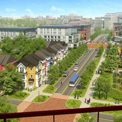
I can't help but notice how much the area around me actually looks like the one representative picture though, minus some things like the mid-rise buildings which are to start building soon, the trees being smaller, and the fact that for some reason that Perkins+Wills seem to have taken extremely imaginative liberties that funding for an entire (apparently translucent) tram line would just appear out of nowhere and that there would be no problems at all with building an entirely new line with stop spacing equal to the length of a stop literally right next to the Metro Line that would just wander off to the south along 109 Street all of the way to downtown and yeah maybe there are certainly reasons that things didn't turn out 100% identical to how Perkins+Wills imagined things.

Screenshot 2024-12-30 at 4.42.03 PM.png
 
Last edited:

Back
Top