Metro Line LRT | ?m | ?s | City of Edmonton

It's a modular design, just extend it.

Need an extra shelter? Use the one from Millgate.
Here you are complaining about the temporary nature of the NAIT station and the expense of building it in the first place now you want to relocate and add extra expense for an extended platform for a temporary station. Sigh.
 
Here you are complaining about the temporary nature of the NAIT station and the expense of building it in the first place now you want to relocate and add extra expense for an extended platform for a temporary station. Sigh.
It's really irritating when people strawman my arguments to score internet points.

Sure I don't like the NAIT temporary station especially the bit about it being too short, but that is done.

If the City absolutely has to build Ellerslie station at-grade, then I say they build a temporary structure and leave the possibility open for a grade separation later. In that case then the NAIT station can be used with appropriate modifications to allow 5 cars.
 
Need an extra shelter? Use the one from Millgate.
Demolished.

Cannot accommodate a five car consist only three. Recycle plant.
To be clear, we're talking about the shelter structure which is modular, not the platform as well. The platform will most likely be demolished.

When building the SLRT extension, modular shelter buildings were installed at the temporary Southgate TC. Later, they were relocated to Southgate TC while the main building was still closed, and finally, they were combined together and used to rebuild Jasper Place TC. Since the Jasper Place has been rebuilt completely.
I can't think of too many uses for the NAIT shelters right now. Perhaps replace the building at Capilano?
 
Demolished.


To be clear, we're talking about the shelter structure which is modular, not the platform as well. The platform will most likely be demolished.

When building the SLRT extension, modular shelter buildings were installed at the temporary Southgate TC. Later, they were relocated to Southgate TC while the main building was still closed, and finally, they were combined together and used to rebuild Jasper Place TC. Since the Jasper Place has been rebuilt completely.
I can't think of too many uses for the NAIT shelters right now. Perhaps replace the building at Capilano?
Temporary shelter at Ellerslie. Really. Sooo Edmonton. The NAIT station was always meant to be temporary as the airport lands were not available at the time. Ellerslie unfortunately is going to be permanent whether we like it or not it is not a stop gap solution until they decide what to do.
 
Hello, Skyrise. I have goodies from my walking tour of the new Metro Line extension into Blatchford.

First up, we have the new plaza and utilities building. While I can’t speak for the daytime look, it looks lovely with its nighttime facade lighting. There are some reasonably comfortable spots to sit as well.
IMG_0947.jpeg

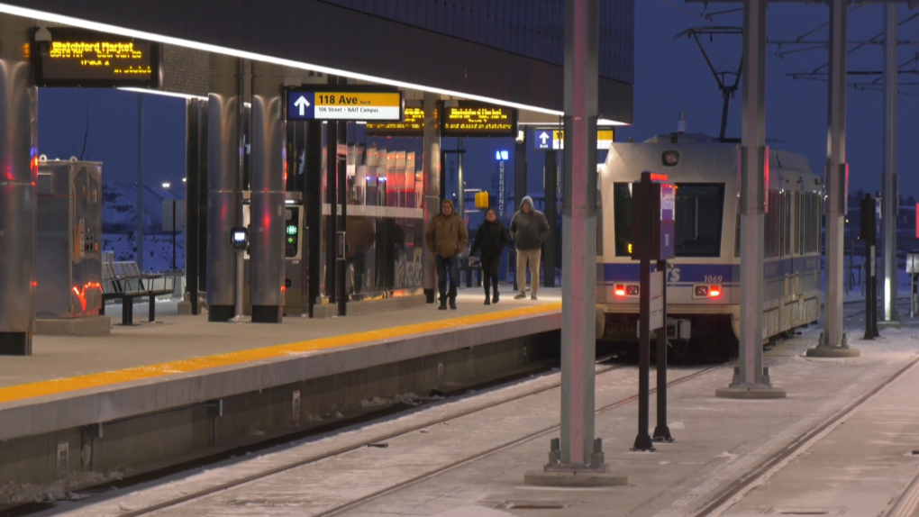
Now onto the new portion of the line that will be the most travelled in the coming years: the new NAIT Station!
IMG_0949.jpegIMG_0950.jpegIMG_0951.jpegIMG_0953.jpegIMG_0952.jpeg
Gorgeous station. Sleek modern design, well-lit, fancy ceiling light features, warm glass-enclosed shelters and station signage that stands out like a beacon. And all-in-all, a pretty cool look for Edmonton’s first side-loading high-floor station.

The alignment through Blatchford is fenced off with tension-wire as opposed to chain fencing that we’ve previously seen. The OCS pylons also have a distinctive design. Bike paths, which I didn’t realize were for bikes only and not shared-use paths, run on both sides of the alignment, and trees adjacent to the tracks will help to provide visual and auditory screening. The track is embedded the whole way except for one segment where the crossover is.
IMG_0954.jpegIMG_0955.jpegIMG_0948.jpegIMG_0956.jpegIMG_0957.jpegIMG_0958.jpegIMG_0959.jpeg
North of NAIT Station, I counted 3 roadway crossings, where there are separate traffic lights for the bike lanes, as well as another pedestrian crossing. Indeed, there are no crossing gates; all pedestrian crossings use regular crosswalk lights, as well as those LED train warning lights that I showed in a previous post (which look like they belong in Galaxyland rather than along a rapid transit line). Traffic lights are used instead of gates to stop cars, but fortunately, there are no turning movements at these crossings so we might be able to avoid crashes caused by right turns on red lights. Nevertheless, I hope we backtrack on this decision to not use crossing gates. The trains have a speed limit of 30 km/h along the entire new alignment, and the lack of crossing gates definitely plays a part. It’s already fenced off and separated from other modes, so we might as well add gates and raise the speed to 50 km/h, so that we preserve the Metro Line’s eventual function as a rapid cross-town route.
 
I hiked all the way up to Blatchford Station, which is closed, but I was close enough to see that it used the exact same design as the new NAIT Station i.e. 10/10. There are also tail tracks, which I imagine will be utilized for storing extra trains for more efficient deployment.
IMG_0960.jpegIMG_0961.jpegIMG_0962.jpegIMG_0963.jpegIMG_0964.jpeg
It really bugs me how far it is from any of the development in Blatchford, and isn’t at least being used as a node for feeder bus routes in the interim, but hopefully, that changes over time. The lack of connectivity between Blatchford and the extension should be resolved this summer too, and hopefully, access to 109th Street should open up soon. A lot of the land around the alignment is also slated to be taken up by the NAIT expansion, which may take a long time to materialize, but will hopefully really tie the area together.
IMG_0967.jpeg
 

Back
Top