


Member Bio
- Joined
- Sep 22, 2015
- Messages
- 10,218
- Reaction score
- 23,060
- Location
- Edmonton, Alberta, Canada
So this is a bit of an experiment to hopefully generate some discussion, and maybe kick off a theme of similar discussions regarding the urban realm in Edmonton. For lack of a more creative title for the series, I'm calling them Big YEGdeas.
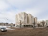
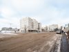
The first of such revolves around this particular bit of desolate landscape next to one of the best public realms in the city; that is, the Government Transit Centre, next to the beautiful Alberta Legislature grounds:


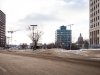
The transit centre is virtually unused outside of peak hours. Even at peak times, it only serves seven routes. Surrounding the terminal are two roadways, 107 St. and 107A St., the former of which is unnecessarily wide even with parking along the street (despite not being a major or even a remotely busy street):

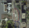
Here's an aerial view of the area:

(The transit centre is outlined in red; a small surface lot in blue, and there's a green arrow indicating the location of a stair that connect to 98 Ave above.)
This is all right next door to the Legislature grounds, and right outside the beautiful and newly refurbished Federal Building. Many pedestrians can be seen criss-crossing this area, and I know many cyclists use this street to get in and out of downtown daily; meanwhile, observed vehicle traffic is extremely low.
So let's make it better.

Thoughts?
See the custom map and all of its elements here:
https://drive.google.com/open?id=16IwLT294btkVXEJgDkXu4X-uNEY&usp=sharing
The first of such revolves around this particular bit of desolate landscape next to one of the best public realms in the city; that is, the Government Transit Centre, next to the beautiful Alberta Legislature grounds:
The transit centre is virtually unused outside of peak hours. Even at peak times, it only serves seven routes. Surrounding the terminal are two roadways, 107 St. and 107A St., the former of which is unnecessarily wide even with parking along the street (despite not being a major or even a remotely busy street):
Here's an aerial view of the area:
(The transit centre is outlined in red; a small surface lot in blue, and there's a green arrow indicating the location of a stair that connect to 98 Ave above.)
This is all right next door to the Legislature grounds, and right outside the beautiful and newly refurbished Federal Building. Many pedestrians can be seen criss-crossing this area, and I know many cyclists use this street to get in and out of downtown daily; meanwhile, observed vehicle traffic is extremely low.
So let's make it better.
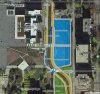
- Realign 107 St. into a single, two-lane street - one lane each direction (black centre area)
- Design for and set vehicle speed limit at 30 km/h
- Add protected bike lanes on west side to connect into the downtown minimum grid (coming 2017) (orange)
- Buffer the sidewalks and bike lanes with on-street paid parking (yellow)
- Retain curb pull-ins for bus stops in either direction (dark blue)
- Reclaim the south surface parking as additional parkland (green)
- Sell the surplus land for mixed-use development requiring strong pedestrian realm (light blue)
- A new one-way (southbound) laneway for accessing the new properties
- Accessed via existing laneway between 106 and 107 St.
- Required due to grade divergence with said laneway
- Includes pedestrian-friendly design elements
- Exits onto 107 St.
- Build a more grand connection to 98 Ave. via a feature staircase and ramp, surrounded by a micro-plaza (also green)
- Enhance pedestrian connections and safety with:
- Curb bulbs at all crossings
- Signalized scramble at 98 Ave
- Signalized mid-block raised crosswalk by Federal Building
- Short signal timings to minimize waits for all modes
- Coordinate signals to minimize or eliminate interactions between pedestrians, cyclists, and vehicles
Thoughts?
See the custom map and all of its elements here:
https://drive.google.com/open?id=16IwLT294btkVXEJgDkXu4X-uNEY&usp=sharing
Attachments
Last edited:
") I put this particular bug in the ear of some Councillors and MLAs, and got a pretty positive response so far. It also attracted the attention of Elise Stolte at the Journal, who reached out to me to chat about it since she's actually been working on a similar story independently.
I put this particular bug in the ear of some Councillors and MLAs, and got a pretty positive response so far. It also attracted the attention of Elise Stolte at the Journal, who reached out to me to chat about it since she's actually been working on a similar story independently.